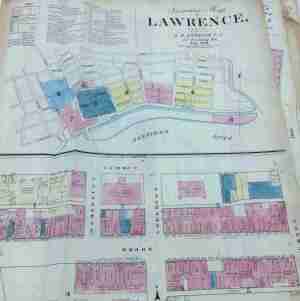
 The Lawrence Public Library has just acquired six Sanborn maps of Lawrence, Massachusetts. With the 1895 map the Library already owned the list includes these years: 1873, 1883, 1888, 1895, 1911, and 1956. They are in remarkably good condition and will become a wonderful resource for the community.
The Sanborn Insurance Maps were originally created for assessing fire insurance liability in urbanized areas in the United States. The maps include detailed information regarding town and building information in approximately 12,000 US towns and cities from 1867 to 2007. The maps survive as an unmatchable tool to the growth and urbanization of American cities. They are a highly useful for all kinds of research: city planning, preservation, historical, genealogy, and urban geography.
Mapping for insurance, and specifically fire insurance, purposes had existed for a century prior to the emergence of the Sanborn Company, first beginning in London in the late 18th century. In the decades following the end of the Civil War, fire insurance mapping grew rapidly, mirroring the flourish of growth in the country, the rebuilding of the South and massive westward expansion. Factors such as the Homestead Act, railroad construction, the Second Industrial Revolution and massive immigration to the United States all fostered huge population growths, urbanization, and heightened demand for mapping.
The Sanborn Company began making fire insurance maps in 1867 when founded by Daniel Alfred Sanborn, a surveyor from Somerville, Massachusetts. The Sanborn Map Company created maps for fire insurance assessment in the US, and within several decades became the largest and most successful American map company. Sanborn was headquartered at 629 Fifth Avenue in northern Pelham, New York, but had regional offices in San Francisco, Chicago, and Atlanta. The Sanborn Company sent out legions of surveyors to record the building footprints and relevant details about these buildings in all major urbanized areas regarding their fire liability. It was because of these details and the accuracy of the Sanborn maps, coupled with the Sanborn Company’s standardized symbolization and aesthetic appeal that made the Sanborn Company so successful and their maps so widely utilized.
The maps were utilized by insurance companies to determine the liability of a particular building through all the information included on the map; building material, proximity to other buildings and fire departments, the location of gas lines, et cetera. The very decision as to how much, if any insurance was to be offered to a customer was often determined solely through the use of a Sanborn map. The maps also allowed insurance companies to visualize their entire coverage areas; when an agent sold a policy he could color in the corresponding building on the map and thus visualize the companies’ coverage of an area.
Filed under: map, S | Tagged: Lawrence MA, Sanborn Insurance Maps |


[…] the conventional Lawrence atlases of 1875, 1896, 1906, and 1926 the Library also has a number of Sanborn atlases for starting in 1863 , an Essex County atlas, and a Massachusetts commercial atlas from […]
[…] Sanborn maps […]